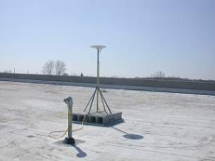
GPS Site Information:
Location: St.
Louis, Missouri
Organization: St. Louis Community College, Civil Engineering Dept.
Station Name: Flo Valley
Latitude: 38° 46' 01.85247" N
Longitude: 90° 17' 14.50523" W
Ellipsoid Height of APC: 155.772m
(Last updated: 200704161055)
|
GPS
Receiver Specifications:
Receiver Model:
5700
Manufacturer: Trimble Navigation, LTD
Antenna: Zephyr Geodetic
Elevation Mask: 10 Degrees
Logging Interval SSF: 1 Second
Logging Interval DAT & RINEX: 5 Seconds
Operation Time: Log files are created 6 day/wk 8am-9pm (CDT -5,CST -6)
Rollover: Every hour

|
|
ANNOUNCEMENT:
Data is temporarily unavailable directly from this site. We are upgrading to a new system to better serve you!
General Operation: Files can be used for
Mapping grade GPS (Differential and Carrier Phase solutions) at roughly
up to a 150 mile radius from the base location. The reference coordinate
in the data files is the static survey coordinate and is fixed, but
it is suggested that it be checked against the published data before
processing any data. Files can also be used
for Post-processed high precision Survey grade GPS (Kinematic, Fast
Static, & Static) - just treat this station just like another receiver
set on a high precision point and you have an additional baseline. See
your receiver manual and/or specifications for details on accuracies.
File Naming: The files are organized in directories according
to the type of data i.e. (Almanac, Dat, Rinex, Ssf).
The file naming
convention is as follows: yymmddhh.exe Where “yy” is used to as the
year, “mm” is the month, “dd” is the day, and “hh” is the hour in Universal
Time Coordinated (UTC).
Data Storage: Files are normally available on line for 14 days, after which they will be deleted. Data is not archived prior
to deletion and is therefore unrecoverable. Users are encouraged to
download data as soon as possible. There is a 24 hour latency on
files.
To Download Files: To download the files please follow
these steps:
- Select the file
format that you are interested in downloading from the list below:
SSF
RINEX
DAT
ALMANAC
- Select the file
name that you wish to copy to your computer.
- When asked, specify
the location on your hard drive where you want to store the file.
- Repeat step three until the file(s) are copied to your
system.
- Double click on each file to uncompress it.
- You are now ready to use the
file(s) for differential correction.
DATA
USE WARNING: St. Louis Community College is providing this information in good faith
and shall in no event be liable for any lost profits, and special, indirect
or consequential damages to any party, arising out of or in connection
with the use or the inability to use the data hereon or the services
provided. St. Louis Community College provides this data and it's services as a convenience
to the public. Furthermore, St. Louis Community College reserves the right to
change, revise, or otherwise discontinue published data and/or these
services at any time without further notice.
For
more information contact Rich Unger, Civil Engineering, at
314-513-4319 or email him at:
runger@stlcc.edu
|